
GEOLAND SURVEY
Let's talk about geospatial with fun
Clients
87
Since 2022
Projects
396
✓ Finish 391 (98%)
Order
1396
Since 2022
Let's talk about geospatial with fun
Clients
87
Since 2022
Projects
396
✓ Finish 391 (98%)
Order
1396
Since 2022
Lorem ipsum dolor sit amet, consectetur adipisicing elit. Saepe est aliquid exercitationem, quos explicabo repellat?
Lorem ipsum dolor sit amet, consectetur adipisicing elit. Saepe est aliquid exercitationem, quos explicabo repellat?
Lorem ipsum dolor sit amet, consectetur adipisicing elit. Saepe est aliquid exercitationem, quos explicabo repellat?
Lorem ipsum dolor sit amet, consectetur adipisicing elit. Saepe est aliquid exercitationem, quos explicabo repellat?
Lorem ipsum dolor sit amet, consectetur adipisicing elit. Saepe est aliquid exercitationem, quos explicabo repellat?
Lorem ipsum dolor sit amet, consectetur adipisicing elit. Saepe est aliquid exercitationem, quos explicabo repellat?
A system used to manage, analyze, and visualize spatial data. Examples include mapping infrastructure, land zoning, or identifying flood-prone areas.
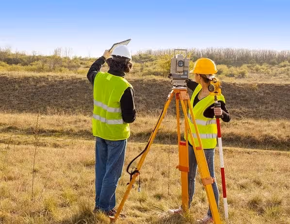
Accurate measurement and mapping of land positions using tools like total stations or GNSS. Commonly used for construction planning, land ownership boundaries, or spatial development.
A technique for creating maps or 3D models from aerial or drone imagery. Ideal for topographic mapping, mining volume calculations, or large-scale area documentation efficiently.
Discover the latest trends, tips, and best practices in modern geospasial surveying
"Geoland Survey's attention to detail and professionalism set them apart in the industry. Their innovative approach to geospatial challenges consistently delivers outstanding results. Their ability to adapt to complex project requirements while maintaining high standards is remarkable."

"The team's dedication to client satisfaction is evident in every project they undertake. Their responsiveness and willingness to go the extra mile make them a reliable partner for any geospatial needs. Geoland Survey's ability to deliver on time without compromising quality is truly commendable."

"Their remote sensing analysis provided invaluable data that greatly enhanced our project outcomes. Geoland Survey's spatial analysis services are top-notch, delivering actionable insights with remarkable accuracy."

"We highly recommend Geoland Survey for their exceptional geospatial services and client-focused approach. Their dedication to innovation and continuous improvement sets them apart as industry leaders. We look forward to future collaborations."

"Geoland Survey's comprehensive geospatial solutions have been instrumental in our project's success. Their commitment to excellence ensures reliable and accurate outcomes every time. The insights provided by their spatial analysis have been invaluable in shaping our strategies."


Find out all the essential details about our platform and how it can serve your needs.
Halaman ini masih statis, belum bisa digunakan.